Yes, we all know Seattle is totally “metronatural” and you’re automatically more “outdoorsy” than your friends in other cities, just by virtue of living here. But sometimes experiencing a metronatural metropolis isn’t enough on its own. Sometimes you need to get away from the hubbub, to escape to a world where there are no Metro buses belching diesel fumes, or Microsofties running you down in their Priuses, or bicycle commuters clipping you with their panniers. And that’s when it’s time to pack up some PowerBars, lace up your Merrells, and head out to the city’s pedestrian overpasses.
There are dozens of these pedestrian-only facilities in the city. Many of them are the exclusive domain of shoppers and office workers, who are allowed to travel, in cosseted comfort, between parking garage and retail/mixed-use establishment without ever being exposed to the elements. This, of course, defeats the whole purpose of a pedestrian bridge—which is to savor the views, the fresh air, and the exercise. Fortunately there are a few pedestrian peaks in town that provide this kind of true “urban getaway” experience.
MARTIN LUTHER KING WAY/RAINIER AVENUE SOUTH PEDESTRIAN OVERPASS
Year of Construction: 1976
Elevation Gain: approx. 17 feet
Difficulty: Moderate
Hazards: Large oak-tree branches overhang the easternmost portion of the bridge, reducing clearance and obstructing the visual field. A Philly’s cheesesteak purveyor is nearby.
This overpass leaps once, then twice, across the two broadest thoroughfares in the Rainier Valley, forming a kind of inner-city version of The Brothers in the Olympic range. With a brute elegance that many of the city’s fancier bridges lack, this cement structure also boasts a gently arching slope that makes it more exciting to traverse than the city’s now-customary flat bridges. Access is achieved via three curving ramps that spiral up to the bridge from ground level, one at each end, a third rising in the triangle created by the intersecting streets. These ramps encircle public art, created on poles by native youth. At the two summits, there are excellent views of the Franklin High athletic field to the northeast and an Ace check-cashing outlet directly south. Rest, and a possible lunch spot, can be found below on four wide, concrete stumps at each of the three bridgeheads.
RAY MOORE BRIDGE
Year of Construction: 2004
Elevation Gain: 17.5 feet
Difficulty: Strenuous
Hazards: Dense, sketchy Aurora Avenue “greenbelt” at the western terminus. Roar of traffic. Bizarrely out-of-place faux-Southwest color scheme.
Despite its pointy spires, little diamond shapes, and soft brick-and-turquoise hues, this bridge does not connect an AMC Cinema with the mall food court. Quite the contrary: Conquering the Ray Moore requires you to ascend from the narrow Aurora Avenue sidewalk at about Galer Street; pass over the treacherous, inhumane freeway; and alight on an isolated Queen Anne hillside. An 8-foot wire-mesh “throw fence” lining the bridge—designed to deter pedestrians from “throwing” anything on the speeding vehicles below—provides little protection from bracing winds and powerful rain gusts. A steep staircase on the western side leads through a series of semi-switchbacks, finally depositing you on Sixth Avenue North, in front of what is likely the home of a RealNetworks executive. Bridge views to the east are of Lake Union and Capitol Hill; to the south, the interior of several Aurora Avenue apartments.
WEST LAKE UNION CENTER PEDESTRIAN BRIDGE
Year of Construction: 1995
Elevation Gain: 22 feet
Difficulty: Moderate
Hazards: Bridge crosses at disorienting, nonperpendicular angle to the road below. Snack bar at the western terminus appears to keep irregular hours.
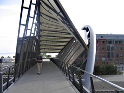
A charming cable-stayed suspension bridge with a central mast tower and concrete viewing platform, this 130-foot-long, gentle transverse is reached via a Westlake Avenue North staircase with ample nearby parking. Vaguely reminiscent of the Verrazano-Narrows Bridge, where runners in the New York Marathon start their race, this structure can inspire similar feats of endurance: A series of staircases at the western end, adjacent to the snack bar and office park, lead up to Dexter Avenue, then onward to the Ray Moore Bridge, past the RealNetworks executive’s house, and to the summit of Queen Anne Hill. From the bridge’s easternmost end, there are exquisite views of the South Lake Union marina. The western side brings into view the offices of Seattle Reproductive Medicine and hotties on their way into the L.A. Fitness club.
BELL STREET FOOTBRIDGE
Year of Construction: 1996
Elevation Gain: N.A.
Difficulty: Easy
Hazards: High-pitched screeching of passing trains. Lanyard-equipped Port visitors. Lost cruise-ship passengers. Excessive postcard-perfectness.
Built by the Port of Seattle—an organization not exactly known for pinching pennies—this is the Mont Blanc of elevated walkways: spectacular in scenery, attracting a large, monied crowd, with top-of-the-line facilities. Emerging from a blank hillside just off Western Avenue, this double-decker skybridge powers its way straight across Elliott Avenue, eventually depositing you at the Port’s new conference facility, featuring the perennially empty Odyssey Maritime Museum. But as every adventurer knows, the journey is more important than the destination, and that couldn’t be truer here. While the insulated bottom deck leads directly to an Art Institute garage, the top deck is en plein air, with unsurpassable 360-degree views of the city and waterfront. The western end of the bridge leads to a fantastic roof deck equipped with free viewfinders.
HELIX PEDESTRIAN BRIDGE
Year of Construction: 2003
Elevation Gain: 35 feet
Difficulty: Moderate
Hazards: Dizzying illusion of sway causes Wages of Fear flashbacks. In the event of an accident, hours may pass before the next bridge user comes along and finds you.
A Disneyland ride of an overpass, this showpiece gateway to the Amgen corporate campus is designed to replicate the structure of the DNA molecule. It’s hella helical! Three steel pipes arch and twist their way 60 feet above the railroad tracks, mimicking the sugar-phosphate spirals of a DNA helix, while dozens of spinning, vertical trusses represent the nitrogenous “rungs” that carry genetic code. Woven fabric provides modest insulation from severe weather systems, and restrains you from tossing trail mix at the trains passing underneath. The bridge’s eastern slope provides a window into the changing Seattle ecosystem: Directly south, you’ll see some of what remains of the city’s old growth (Blackstock Lumber); to the north, some of the region’s newer, invasive species (Bria Pilates). For magnitude of spectacle, solitude, and sense of grandeur in the middle of nowhere, hiking the helix can’t be beat.